🚢

Maritime OSHA Evacuation Maps 2025

Anchored in Safety - Create Compliant Maps in Seconds

Shipyard and port facility evacuation maps. Generate professional maps free and instant with our AI-powered map maker.

Free instant preview • No credit card • Download in seconds

Get Your Free OSHA Risk Assessment

Identify compliance gaps specific to Maritime in minutes. Our quick assessment helps you understand your evacuation planning requirements.

Start Free Assessment

From Napkin Sketch to Professional Maritime Evacuation Map

Our AI creates professional evacuation maps specifically designed for Maritime facilities in seconds

Works with photos, scans, PDFs, CAD files, or even hand-drawn napkin sketches

  • 100% OSHA Compliant
  • Instant Results (~30 sec)
  • Print-Ready (11x8.5" or 17x11")

Why Maritime Professionals Choose Our AI Map Generator

Do I need design skills to create an evacuation map?

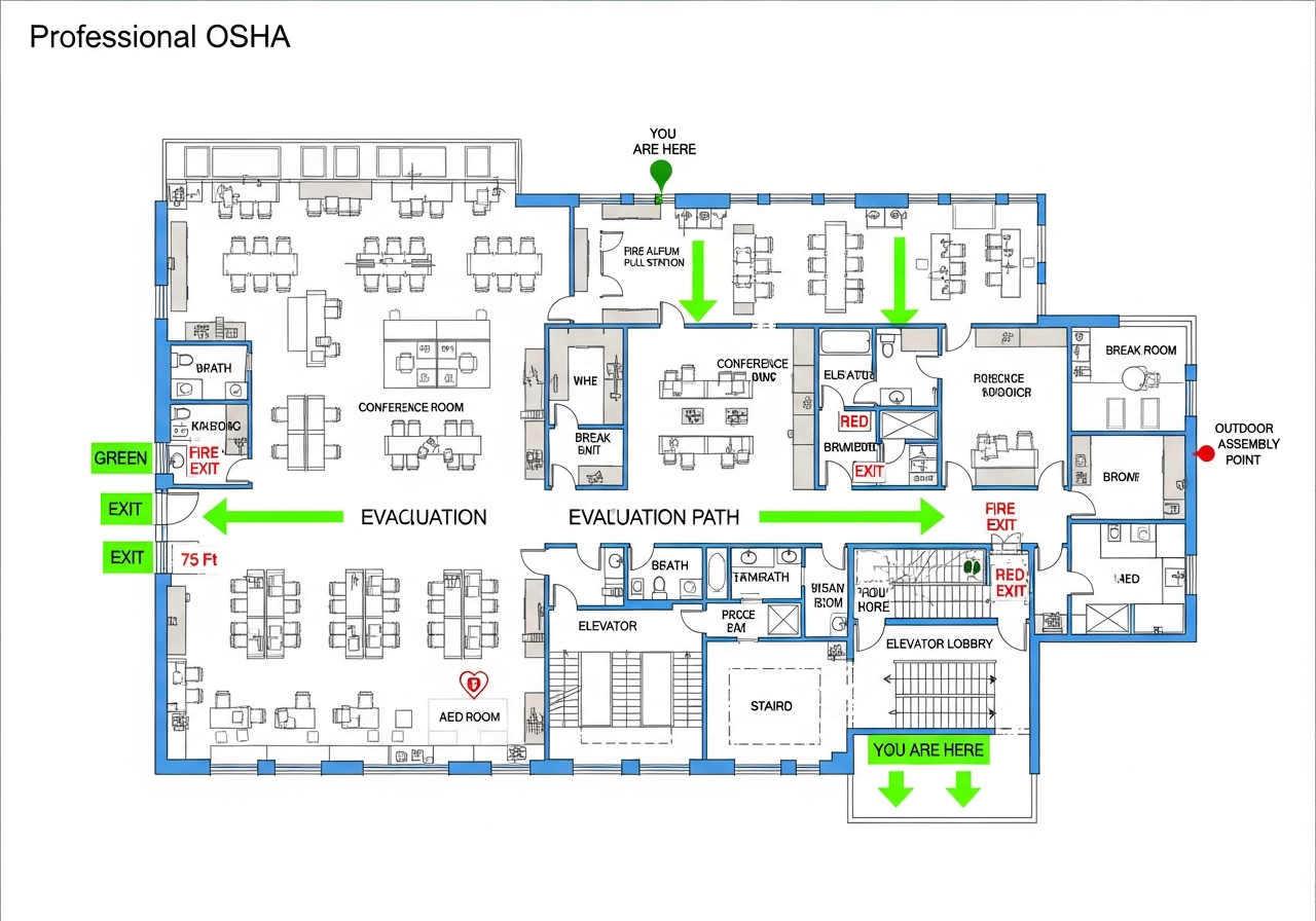
No design skills are required. Our AI understands hand-drawn floor plans, smartphone photos, scanned blueprints, and PDF documents. Simply upload any representation of your facility layout and receive a professional-grade emergency evacuation map instantly.

Are the generated maps OSHA compliant?

Yes, every generated map meets OSHA 29 CFR 1910.38 Emergency Action Plan requirements including clearly marked exit routes, fire extinguisher locations within 75-foot travel distance, assembly points, YOU ARE HERE markers, and accessibility accommodations per ADA guidelines.

Can I update my evacuation map after renovations?

Yes, unlimited revisions are included. If you renovate your office or add a new emergency exit, simply re-upload your updated floor plan and generate a new compliant map instantly. All free maps include unlimited regeneration so you always have current evacuation documentation.

What types of buildings can use this evacuation map generator?

Our generator works for any building type including warehouses, manufacturing plants, healthcare facilities, schools, retail stores, and office buildings. The AI adapts to any facility size and layout, generating appropriate exit routes, fire safety equipment placement, and assembly point locations.

Industry-Specific Expertise

Maritime Safety: Where Land Meets Water

Operational safety insights designed specifically for Maritime professionals

Operational Realities & Best Practices

Vessel Movement
Challenge:Ships arrive and depart continuously
Best Practice:Traffic control and communication protocols
Multi-Employer Environment
Challenge:Longshoremen, ship crew, and terminal operators
Best Practice:Coordinated safety programs across employers
Water Hazards
Challenge:Drowning risk from dock edges and vessel access
Best Practice:Life ring placement and rescue capability

Safety-Integrated Workflow

1
Vessel Arrival
Gangway inspection and mooring verification
Safe vessel access
2
Cargo Operations
Load planning and equipment inspection
Safe cargo handling
3
Vessel Departure
Area clearance and line handling safety
Safe unmooringoperations

Critical Equipment Zones & Requirements

Pier/Dock Face

Hazards:
  • Falls into water
  • Struck-by vessels
  • Mooring line snap
Map Requirements:
  • Life ring stations
  • Exclusion zones during mooring
  • Snap-back zones marked

Container Yards

Hazards:
  • Top handler traffic
  • Stack collapse
  • Struck-by containers
Map Requirements:
  • Pedestrian lanes
  • Stack limits
  • Traffic separation

Ship Holds

Hazards:
  • Confined space
  • Cargo shifting
  • Access hazards
Map Requirements:
  • Atmosphere testing
  • Securing verification
  • Ladder inspection

Shift-Specific Considerations

Vessel Operations
Risks: 24/7 work around vessel schedules, Weather delays compress work, Fatigue
Mitigations: Crew rest requirements, Weather holds, Supervision
Night Shift
Risks: Visibility, Reduced traffic awareness, Fatigue
Mitigations: Lighting requirements, Enhanced communication, Break enforcement

Seasonal Factors

Storm Season
Vessel schedule disruption and weather hazards
Storm plans and yard securing
Peak Season
Maximum cargo volume and traffic
Staffing and traffic management

Technology Integration for Safety

Terminal Operating System
Equipment and cargo tracking
🛡️Know what is where and who is operating
CCTV Coverage
Continuous operational monitoring
🛡️Incident detection and investigation
AIS Integration
Vessel tracking and movement prediction
🛡️Advance warning of vessel arrivals

Get Your Maritime Evacuation Map Now

Industry-specific compliance in under 2 minutes. All maritime hazards and OSHA requirements included.

Trusted by maritime facilities nationwide

Maritime Workplace Safety Compliance Generator

Upload your floor plan and get a professional OSHA-compliant maritime evacuation map in seconds

📊 5 of 5 Free Maps Left

Create Your Maritime Evacuation Map

📷
Clear ImageUse a clean, high-quality scan or photo
↔️
Correct OrientationImage should be right-side up, not rotated or sideways
🔍
No ZoomCapture the entire floor plan, avoid zooming in on sections
💡
Good LightingThe clearer and less blurry, the better results
📁

Drag & drop your floor plan here

or

PNG, JPG, PDF - Hand-drawn sketches work too!

🔒Your files are private: never shared, stored temporarily, deleted automatically.

Compliance Options

Generate bilingual map with English + Spanish labels

ℹ️Adds Spanish translations (Español) to all text on the map
🔥 NEW

Customize Your Map

Add special requests for your safety map - tell our AI exactly what you need!

  • 🎯Add specific details like "Mark fire extinguisher near kitchen"
  • 📍Request specific zones: "Highlight assembly point in parking lot"
  • 🏥Add safety equipment: "Include AED location near reception"
0/2000

Quick Add:

See What You'll Get

Real examples of AI-generated OSHA-compliant evacuation maps

Corporate Office - California - OSHA-compliant evacuation floor plan with marked exits and fire safety equipment
🔍 View Full Size

Corporate Office - California

TechnologyCalifornia
Distribution Center - Texas - OSHA-compliant evacuation floor plan with marked exits and fire safety equipment
🔍 View Full Size

Distribution Center - Texas

WarehousingTexas
Medical Center - New York - OSHA-compliant evacuation floor plan with marked exits and fire safety equipment
🔍 View Full Size

Medical Center - New York

HealthcareNew York
Restaurant - Florida - OSHA-compliant evacuation floor plan with marked exits and fire safety equipment
🔍 View Full Size

Restaurant - Florida

RestaurantFlorida

Ready to create your own professional evacuation map?

Register for 5 free maps with unlimited revisions
🚢

Maritime Safety Requirements

Industry Fatality RateVaries by specific operations
Injury RateIndustry average: 2.8 per 100 workers
Industry BenchmarkLeading Maritime facilities maintain 100% evacuation drill completion

🚨 Top Safety Incidents

  • Slips and falls
  • Ergonomic injuries
  • Fire emergencies

📚 Required Training

Emergency EvacuationFire Extinguisher UseFirst Aid/CPR

🔥 Emergency Scenarios

Fire EvacuationSevere WeatherMedical Emergency

✅ Compliance Checklist

  • Posted evacuation maps
  • Clear exit routes
  • Emergency contact lists
  • Annual drill documentation
"

Cut our map update time from 6 hours to 10 minutes.

★★★★★
Sarah M., Hospital Safety Director

Create a professional evacuation map designed specifically for Maritime facilities

✓ Industry-specific hazards marked✓ OSHA-compliant layout✓ Print-ready in seconds
⚠️ OSHA COMPLIANCE ALERT

Maritime OSHA Compliance Alert

Maritime industry fatality rate: 3.5 per 100,000. 150 workplace deaths annually.

💀3.5 per 100,000Fatality Rate
🩹2.8 per 100Injury Rate
☠️150Annual Deaths
🏥27,734Annual Injuries
🚨

OSHA Penalty Structure - Know Your Risk

Other-than-SeriousUp to $16,131Per violation
Serious ViolationUp to $16,131Per violation
Willful / RepeatUp to $161,323Per violation
Failure to Abate$16,131/dayAfter citation deadline

Avoid costly penalties with compliant evacuation maps

⚠️

Top OSHA Violations in Maritime

Maritime sees 8+ common violation types. Is your facility compliant?

#129 CFR 1910.37

Exit Routes - Obstructed or inadequate emergency exits

Frequency:12% of general industry inspections citations
Typical Penalty:$3,500-$12,000
✓ Prevention:
  • Keep exits unobstructed
  • Maintain illuminated exit signs
#229 CFR 1910.38

Emergency Action Plans - Missing or inadequate EAP

Frequency:11% of general industry inspections citations
Typical Penalty:$4,000-$14,000
✓ Prevention:
  • Develop written EAP
  • Train employees on procedures
#329 CFR 1910.157

Fire Extinguishers - Inspection and training requirements

Frequency:10% of general industry inspections citations
Typical Penalty:$3,000-$10,000
✓ Prevention:
  • Conduct monthly visual inspections
  • Annual maintenance by certified professional
#429 CFR 1910.1200

Hazard Communication - Chemical labeling and SDS requirements

Frequency:9% of general industry inspections citations
Typical Penalty:$4,500-$15,000
✓ Prevention:
  • Maintain updated SDS for all chemicals
  • Train employees on hazard labels
#529 CFR 1910.303

Electrical Safety - Wiring and equipment hazards

Frequency:8% of general industry inspections citations
Typical Penalty:$5,500-$18,000
✓ Prevention:
  • Maintain proper clearances
  • Use proper covers and guards
#629 CFR 1910.22

General Industry safety violation

Frequency:7% of general industry inspections citations
Typical Penalty:$5,000-$15,000
✓ Prevention:
  • Develop compliance program
  • Train employees
🗺️

Missing Evacuation Maps = OSHA Violation

29 CFR 1910.38 requires emergency action plans with posted evacuation routes. Generate compliant maps in minutes.

Don't Wait for an OSHA Inspection

Get Your Maritime Evacuation Map Today

Professional, OSHA-compliant maps generated in minutes. Avoid penalties up to $161,323 per violation.

View Pricing
✓ OSHA Compliant✓ Print Ready✓ AI-Powered✓ Used by 47,000+ Businesses

Popular States for Maritime

What Your Maritime Evacuation Map Includes

🧯

Fire Extinguisher Locations

Strategically placed per OSHA 75-foot travel distance requirements

🚪

Emergency Exits

Clear, prominent EXIT signs at 1.5" width for easy visibility

➡️

Evacuation Routes

Lime green arrows showing the safest path to exits

👥

Assembly Points

Clearly marked gathering locations outside the building

📍

YOU ARE HERE

Bold markers to help occupants orient themselves quickly

🏥

First Aid Stations

Marked locations for emergency medical supplies

Safety Professionals in Maritime

Join other safety leaders using Fire Exit Evacuation Map Generator

Maritime Hazards & Emergency Planning

Understanding risks specific to maritime facilities

⚠️

Drowning

Drowning requires specific safety protocols and emergency planning.

Reference: 29 CFR 1910.38
⚠️

Crane operations

Crane operations requires specific safety protocols and emergency planning.

Reference: 29 CFR 1910.38
🕳️

Confined spaces

Confined spaces require entry permits, atmospheric monitoring, and rescue procedures.

Reference: 29 CFR 1910.146

Maritime OSHA Compliance Requirements 2025

Key regulatory requirements for maritime facilities

📋

29 CFR 1915

Specific compliance requirements for maritime operations and worker safety.

📋

29 CFR 1918

Specific compliance requirements for maritime operations and worker safety.

Maritime Fire Safety & Evacuation Requirements

🚨

Industry-Specific Emergencies

Maritime facilities face unique emergency scenarios including drowning and crane operations. Professional evacuation maps ensure employees know exactly where to go during any emergency.

📋

OSHA Compliance

OSHA requires maritime facilities to maintain written emergency action plans per 29 CFR 1915. Clearly posted evacuation maps are an essential component of these plans.

👷

Worker Protection

With hazards like crane operations and confined spaces, maritime workers need clear guidance to evacuate safely. Our maps highlight all exits, fire extinguishers, and assembly points.

💰

Avoid Costly Violations

OSHA violations for inadequate emergency planning can cost up to $15,625 per violation. Professional evacuation maps help maritime facilities stay compliant.

Maritime Emergency Preparedness Best Practices

Compliance tips for maritime evacuation planning

1

Post Maps at Every Entrance

Place evacuation maps at eye level (4.5-5 feet) at every building entrance and in high-traffic areas like break rooms and lobbies.

2

Update After Layout Changes

Whenever you reconfigure workstations, add equipment, or modify exits, update your evacuation maps immediately to maintain accuracy.

3

Conduct Regular Drills

OSHA recommends evacuation drills at least annually. Use your maps during drills to reinforce evacuation routes with all employees.

4

Train New Employees

Include evacuation map orientation in new hire training. Every employee should know their nearest exit and assembly point on day one.

5

Account for Shift Workers

Maritime facilities often operate multiple shifts. Ensure all shifts have access to maps and are included in evacuation training.

6

Mark Hazard-Specific Equipment

For maritime hazards like drowning, clearly mark safety equipment locations on your maps.

Free Account Benefits

Create an Account to Unlock

📋

Map History Vault

Never lose a map again

🔄

Unlimited Regeneration

Perfect your evacuation plans

📊

Compliance Dashboard

Stay audit-ready 24/7

🤖

AI Recommendations

Proactive compliance insights

👥

Team Collaboration

Unified safety management

🔔

OSHA Alerts

Never miss an update

📥

Bulk Downloads

Save hours of work

🏆

Priority Support

Expert guidance included

No credit card required

STEP 1 OF 2

Get Free OSHA Compliance Resources

Enter your email to receive free checklists, guides, and compliance tips

"

The free compliance checklist helped us identify 5 safety gaps we didn't know existed!

— Sarah M.Safety Manager, California
256-bit encrypted
No spam, ever
Unsubscribe anytime

By continuing, you agree to our Privacy Policy

🔓 Free Account Bonus

Unlock 5 Free Evacuation Maps

Create your free account in seconds and get instant access to professional, OSHA-compliant evacuation maps.

What You Get When You Register:

  • 5 Free Full-Quality Downloads - Professional maps ready for printing
  • No Watermarks - Clean, presentation-ready evacuation maps
  • Personal Dashboard - Manage all your maps in one place
  • Save & Revisit Anytime - Access your maps from any device
  • OSHA Compliant - Meets 29 CFR 1910.38 requirements
15,000+Maps Generated
4.9/5User Rating
100%Compliant
Sample Output
Sample Maritime OSHA-compliant evacuation floor plan showing emergency exits, fire extinguisher locations, and assembly points
🧯 Fire Extinguishers🚪 Exit Routes📍 You Are Here

No credit card required • Takes 30 seconds • Instant access

Ready to Protect Your Maritime Facility?

Get your professional OSHA-compliant evacuation map in under 2 minutes.

Maritime OSHA Evacuation Map FAQs

What OSHA standards apply to maritime evacuation maps?
Maritime facilities must comply with OSHA standards including 29 CFR 1915, 29 CFR 1918. The primary standard, 29 CFR 1915, requires written emergency action plans with evacuation procedures, exit route markings, and employee training. Our AI-generated maps automatically include all required elements for maritime compliance, ensuring you meet all applicable standards.
What are the unique hazards in maritime that affect evacuation planning?
Maritime facilities face specific hazards including drowning, crane operations, confined spaces. These hazards require specialized evacuation routes that avoid high-risk areas, properly placed safety equipment, and clearly marked emergency assembly points away from danger zones. Our maritime evacuation maps are designed to address these industry-specific challenges with appropriate exit routes and equipment placement.
How often must maritime facilities update evacuation routes?
OSHA requires maritime facilities to review and update evacuation plans whenever changes occur that affect egress or emergency procedures. Best practice for maritime is quarterly reviews due to drowning, crane operations, confined spaces risks. Maps should be immediately updated after equipment moves, layout changes, or when new hazards are introduced. Our platform makes updates fast and maintains version history.
What training is required for maritime evacuation procedures?
Under 29 CFR 1915, maritime employees must be trained on evacuation routes, assembly points, and their specific roles during emergencies. Training should cover recognition of drowning, crane operations, confined spaces scenarios that may trigger evacuation. Annual refresher training is required, with additional training after any plan changes. Our maps include clear visual guides that support effective training.
How do I create an evacuation map for my maritime facility?
Upload your floor plan to Fire Exit Evacuation Map Generator, select "Maritime" as your industry type, and our AI generates a professional OSHA-compliant evacuation map in under 2 minutes. The map automatically includes maritime-specific elements like proper fire extinguisher spacing, exit routes that account for drowning, and compliant assembly point locations.
Are maritime evacuation maps suitable for fire inspections and OSHA audits?
Yes, our maps are specifically designed to meet all OSHA and fire code requirements for maritime facilities. They include compliant exit routes, fire extinguisher locations at required 75-foot travel distance intervals, emergency equipment symbols per 29 CFR 1915, assembly points, AED locations, and first aid stations. Maps are print-ready in sizes appropriate for posting requirements.
What emergency equipment must be shown on maritime evacuation maps?
Maritime evacuation maps must display fire extinguisher locations (Class ABC for general areas, specialized types for maritime-specific hazards), fire alarm pull stations, emergency exits with travel distance compliance, first aid kit locations, AED positions, emergency eyewash stations where applicable, and designated assembly areas. Our AI automatically places all required equipment symbols.